


Since the Russian occupation of two Georgian entities, the so-called administrative ‘border’ moves deeper and deeper into Georgia. The so-called ‘state banner’ titled - Republic of South Ossetia, is getting ever-closer to Georgia’s central highway connecting East to West, while more and more territory is gathered behind the barbed wire fences representing the so-called ‘border’.
According to information provided by the Ministry of Defence of Georgia, the inhabited areas of two villages, Greater and Lesser Khurvaleti, turned out to be on the opposite side of the so-called ‘border’. Moreover, Georgia’s State Security Service provided information to IDFI, according to which inhabited areas of village Gugutiantkari was placed within South Ossetian borders after barbed wire fences were installed in 2013. Media channels certified that villages Zardiantkari and Roreti have been divided. Considerable parts of Dvani, Ditsi, Tsitsagantkari, Jariasheni, Adzvi have been added to the list of seized territories. In the case of Jariasheni, by 2015, almost the entire village has been barbed and placed within occupational border lines.
According to widespread information in the media, the Russian occupational regime is planning to go back to the old administrative borders of the South Ossetian autonomous province which existed during Soviet times. The Russian plan entails to mark the so-called border through village Karipala in order to take over parts of the Baku-Supsa pipeline.
Source: bpn.ge
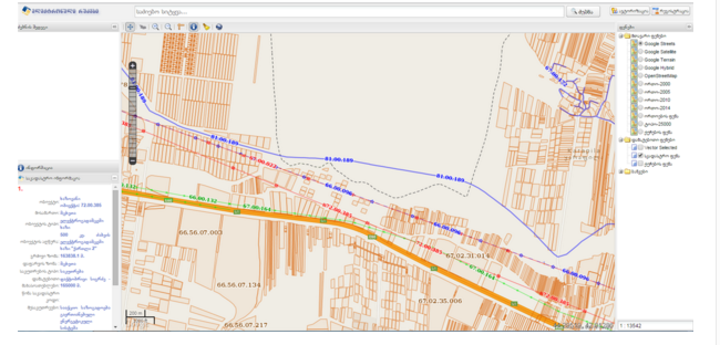
The above-seen map illustrates the boundary line between the so called “South Ossetia” and the rest of Georgia. Blue represents the Baku Supsa pipeline and the doted line represents the new administrative border of the occupied regime.
In some instances the main inhabited areas of the villages remained on the Georgian side; however, the croplands of the village were swallowed beyond the barbed wire. The village inhabitants were left without their primary source of income. There is still fear of a continued “creeping occupation” and the threat of losing the inhabited parts of these villages as well. By using Google Maps, one can see the villages in the immediate vicinity of the so-called border that have to live in constant fear of ending up in South Ossetia one day. These villages are - Upper Niqozi, Ergneti, Ditsi, Mejvriskhevi, Plavismani, Tsitelubani, Karapila, Saribari, Tvaurebi and Avlevi.
The “Institute for Development of Freedom of Information” (IDFI) wanted to find out which villages currently still under Georgian control could end up within the so called ‘administrative boundaries’ in future. At the same time, IDFI wanted to know which map the Occupational regime used in order to continue occupying territory following the 2008 war.
In order to receive such information, IDFI has requested documents from the Administration of the Government of Georgia, the Ministry of Internal Affairs of Georgia, National Security Council of Georgia and the State Security and Crisis Management Council.
The administration of the government has forwarded the request to the Crisis Management Council, the Ministry of Internal Affairs, the Ministry of Defence and the Ministry of Justice. The crisis management coucil has asked the state security service to provide relevant information as did the Ministry of Internal Affairs and the Ministry of Justice.
The state security service has solely provided the list of villages, which are not under control of the Georgian government.
The national security council has provided the “Law on Occupied Territories” which lists those territories. IDFI has sent an additional letter to this institution and received more information later on.
The ministry of defense was the only institution that provided detailed information. This information is shown below.
Former South Ossetian Autonomous District (Tskhinvali Region)
− With the end of the conflict in Tskhinvali region in 1992, with the support of the Russian Federation (including the so called “Peacekeepers”), Ossetian separatists have taken control over the majority of territories in the region:
− Tskhinvali region almost the entire region, administrative center Tskhinvali;
− Java Region administrative center lesser and greater Java;
− Znauri Region administrative center lesser and greater Znauri;
In the same period, the Georgian government had effective control over Akhalgori region, (Excluding 5 Ossetian villages – Tsinagori, Rduleti, Dzukata, Orchosani and Abrevi), as well as villages within the greater Liakhvi valley in the North of Tskhinvali, most villages of the lesser Liakvhi valley in the East and 6 villages of the Znauri region. In addition to that, Georgian jurisdiction covered the Northern parts of the Java region including the Mamisoni Pass and its adjacent territory.
- After the Russian millitary aggression against Georgia in 2008, the Georgian governing agencies and the majority of the Georgian population was expelled from the territories of the former South Ossetian autonomous district ( including Akhalgori and Mamisoni pass) since these areas were now completely controlled by the Occupation regime. The Georgian side lost control over 135 inahbited areas of Tskhinvali region, of which most were ethnically divided, half-Georgian, half-Ossetian. Moreover the villages that were entirely Georgian were completely destroyed. The Georgian populations of the mixed villages were forced to flee.
Territories taken over by Ossetian separatists and Russian occupation forces:
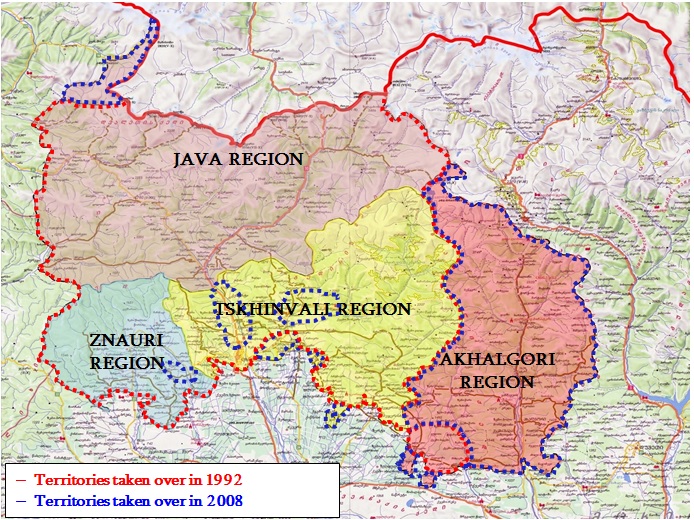
Inhabited areas taken over by the Ossetian separatists and Russian occupational forces since the 2008 War:
Villages in Znauri Region
1. Avnevi 2. Nuli 3. Alibari 4. Tirva 5. Shindara 6. Nabakevi
Villages in Tskhinvali Region
1. Kemerti 2. Kevkhi 3. Dzartsemi 4. Kurta 5. Zemo Atchabeti 6. Kvemo Atchabeti 7. Mamita 8. Kheiti 9. Tamarasheni 10. Prisi 11. Argvitsi 12. Berula 13. Eredvi 14. Ksusi 15. Vanati 16. Jorjiani 17. Satskheneti 18. Beloti 19. Disevi
Town and Villages in Akhalgori Region
1. Small Town of Akhalgori (Administr. Center) 2. Doliani 3. Ikoti 4. Mosabruni 5. Bazuani 6. Akhaldaba 7. Akhalsopeli 8. Akhmaji 9. Bejanaantkari 10. Garubani 11. Ereda 12. Vashlovani 13. Zemo Boli 14. Morbedaani 15. Kvemo Boli 16. Kanchaveti 17. Gdu 18. Boskelta 19. Zemo Gru 20. Tsikhissopeli 21. Tchandari 22. Doreatkari 23. Gavazi 24. Doguzaani 25. Velisa 26. Kara 27. Kutskhoveti 28. Sabarkleti 29. Tchkuneti 30. Dzangati 31. Kvemo Zakhori 32. Armazi 33. Velura 34. Zemo Zakhori 35. Zemo Tskhiloni 36. Zemo Tsiri 37. Zemo Tsolda 38. Zemo Tsubeni 39. Iketi 40. Nadaburi 41. Ukantsiri 42. Kvemo Tskhiloni 43. Kvemo Tsiri 44. Kvemo Tsilda 45. Kvemo Tsubeni 46. Kvitkiri 47. Kuloti 48. Shua Zakhori 49. Shua Tsiri 50. Shua Tsubeni 51. Chachamuri 52. Gezevreti 53. Korinta 54. Gudatsveri 55. Nakhidi 56. Sadzeguri Pirveli 57. Kvemo Alevi 58. Kurta 59. Kochiani 60. Shua Alevi 61. Tsirkoli 62. Kharkelani 63. Largvisi 64. Gareuti 65. Dabakneti 66. Dadianeti 67. Zodekhi 68. Tokhta 69. Martiani 70. Makhiareti 71. Mujukhi 72. Shvelieti 73. Ukanamkhari 74. Ukanubani 75. Kveldaba 76. Chitiani 77. Tskhvati 78. Kharbali 79. Khramistskali 80. Salbieri 81. Delkani 82. Nagomevi 83. Chorchani 84. Dzeglevi 85. Jvarisubani 86. Balaani 87. Eloiani 88. Tinikaani 89. Midelaani 90. Navikhevi 91. Okhiri 92. Pavliani 93. Kareltkari 94. Kenkaani 95. Chigoiani 96. Tsiptauri 97. Tchortchokhi 98. Khozueti 99. Gudita 100. Zemo Bagebi 101. Zemo Kure 102. Kitriuli 103. Monasteri 104. Mskhlebi 105. Kedigora 106. Kvemo Bagebi 107. Tsotaguri 108. Kodijvari 109. Mamulaani 110. Kvemo Gru
Maps used by the separatists and by the Russian border-guards
In order to define the so-called borders (occupation lines) of Georgia’s occupied territories, the border-guards of the Russian Federation and the separatist regime use the topographic maps ( Scale: 1 : 50 000 and 1 : 100 000) of the general staff of the Soviet military published between 1976-1986. It has to be mentioned that the occupational forces of the Russian federation together with representatives of the separatist Ossetian regime have conducted preliminary work to determine the previous administrative boundaries of the former ‘South Ossetian Autonomous District’ and later establish them by demarcation activities. More specifically:
- First of all, there were numerous topographic maps of the Soviet general staff and they have been published throughout different times. At the same time, they differed in the way they defined the boundaries of the former South Ossetian Autonomous District. For example, to define the administrative borderline in Gori region, the Russian side uses the topographic map of 1988 which portrays the locations as of 1984.
- Secondly, during the demarcation and establishment of the administrative border after the 2008 war, the Russian and Ossetian sides did not take into account the complex administrative outline of the South Ossetian district. As a result, much of the Georgian population lost access to the lands that they utilized on every-day basis.
To conclude, after the war in 2008, the Georgian state lost control over 151 settlements (135 in Tskhinvali region and 16 in Kodori Valley); moreover, creeping occupation is still progressing. It is expected that with the political and military support of Russia, Ossetian separatists are going to continue demarcation activities according to the topographic map of 1988, which portrays the administrative boundaries of 1984.
Statement of Civil Society Organizations on the International Day in Support of Victims of Torture
26.06.2026Statement of Georgian Civil Society
06.06.2026 Subscribe to Our News

